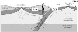
Tectonic plates are jigsaw-like pieces of the thin rigid outer-shell of our planet, which move around colliding and sliding past each other. They are comprised of the crust and the outermost part of the mantle, and are somewhat simpler in nature beneath the oceanic parts than they are beneath the continental parts. Plates are a manifestation of the Earth trying to cool itself – material upwells from the deep mantle and cools forming a rigid shell (a ‘thermal boundary layer’ or plate). We are going to a place on the planet where new plates are formed – the Mid-Atlantic Ridge. New plates – in our case the Nubian and South American plates – rift away from such mid-ocean ridges, thickening as they cool. Based on this idea, the base of a plate can be defined by a given temperature.

Another way of thinking of a plate is in terms of a hard shell overlying the more ductile mantle. The rigid part – the lithosphere – cracks in a brittle manner causing earthquakes, whilst the less viscous part – the asthenosphere – deforms aseismically (without earthquakes). Moving away from a mid-ocean ridge, earthquakes occur deeper and deeper as the plate thickness. This provides a mechanical definition of a plate.
Because the plate is rigid, it will flex and warp in response to bending (e.g. at subduction zones), or as loads are placed on the plate (e.g. oceanic islands like Hawaii). The shape and amount of flexure allows geophysicists to define the thickness of the elastic part – usually called the Effective Elastic Thickness of the plate. This varies from place to place around the Earth.
Another measure of the thickness of the plate comes from seismic imaging. Seismic waves radiating from large earthquakes propagate along the surface of the Earth and are sensitive to the plate and underlying mantle. These seismic ‘surface’ waves propagate faster in the more rigid plate and slower in the underlying asthenosphere. This transition from high to lower velocities defines the seismic thickness of the plate.
A more recent tool for imaging the base of the plate comes from the observations of seismic waves that propagate deep through the body of the Earth (body waves). These are the P-waves and S-waves: P-waves travel faster than S-waves. At abrupt changes in the elastic properties (seismic wavespeeds and density), the seismic waves can change from a P-wave to an S-wave, and vice versa, as they travel upwards toward our ocean bottom seismometers. In the last 10 years, seismic studies have increasingly observed these seismic wave conversions from the base of the plate. This suggests that the bottom of the plate might be much sharper than the thermal models or surface wave results suggest.
A final method for detecting the base of the plate is to use electromagnetic methods to detect changes in the conductivity of the lithosphere and asthenosphere. These methods are particularly sensitive to the presence of fluids, such as pockets of molten rock (termed partial melt). A long held idea is that partial melt may exist in the mantle below the plate, reducing its viscosity and seismic wavespeeds. More recently, it has been proposed that this melt may preferentially accumulate at the lithosphere-asthenosphere boundary, thereby enhancing the seismic phase conversions.
Unfortunately, the thickness of oceanic plates obtained from each of these approaches are often inconsistent. This implies that there are components of the puzzle that we are missing. We need to better understand the distribution of partial melt, the nature of boundaries in the uppermost mantle, and how the minerals, the building blocks of rocks, align in response to mantle convection. The PiLAB experiment will explore these ideas through obtaining an unprecedented seismic and electromagnetic data set from an oceanic plate setting.