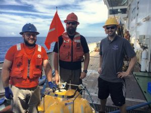
 PiLAB is a unique experiment in many ways, one of which is that ocean bottom seismometers and magnetotelluric instruments are co-located. This allows the comparison of two very different physical properties of the plate and underlying mantle – elasticity and the conductivity – which together offer insights into the nature of tectonic plates, how they form and how they evolve. Today I talked with Jake, Chris and Dan (L to R) who have come to recover the magnetotelluric instruments. Jake and Chris are the research technicians from Scripps. Dan recently left a postdoctoral research position at Scripps for a position at IGNS in his home country New Zealand. This cool-headed group ensures that the instruments are working well, but also offers life-supporting coffee every morning. This group is the brain-child of Steve Constable at Scripps.
Geophysicists have developed a diverse set of techniques for measuring electrical conductivity in the Earth. These techniques are used in a wide range of applications such as mineral exploration, archaeological investigations, detecting military ordnance and munitions, and ground water studies. With PiLAB we are interested in the conductivity structure of the crust and upper mantle beneath the seafloor. Like most geophysical tools, electromagnetic techniques can be divided into active and passive methods. With active methods, electrical and magnetic fields are human-made, where passive methods exploit naturally occurring electromagnetic fields. The Ocean Bottom Magnetotelluric (OBMT) instruments deployed in this experiment measure electrical and magnetic fields induced by natural phenomena. Solar radiation interacting with charged particles in the ionosphere induce a magnetic field in the Earth’s subsurface, which in turn induces electrical or telluric currents. Lightning strikes also work in a similar manner, but at higher frequencies. A secondary magnetic field generated by these telluric currents can be detected using sensitive instruments comprised of coils and electrodes. The strength of the induced field and its phase provide information about the depth and strength of the conductive body. Making such measurements on the sea floor is especially difficult, as sea water is highly conductive and acts like a high-frequency filter. It takes a patient operator – and a precision instrument – to record electromagnetic fields in the solid Earth under these conditions.
 The Scripps Institution of Oceanography, which is part of the University of California San Diego, started making ocean bottom magnetotelluric measurements in the 1960’s. Chip Cox and Jean Filloux pioneered this work and we are benefiting from their legacy. Through the 80’s and 90’s a number of institutions, including Scripps, WHOI, Tokyo, Southampton, Cambridge, Toronto, Adelaide, and others, continued to develop both MT and controlled-source EM instruments. More recently, interest from the oil industry in controlled source electromagnetic methods has led to improvements in instrumentation and has made active-source sea floor EM measurements more routine. EM methods are well-suited to imaging conductive bodies that lie beneath more resistive salt, carbonate or volcanic layers. These layers can cause imaging problems with conventional seismic reflection surveys.
This generation of long-term passive deployments started in 1996 with the MELT experiment on the East Pacific Rise. Significant improvements came from innovations in reducing power consumption, improving the signal to noise, and general advancements in electronics. But equally important has been advances in the mathematical treatment of the data and the inversion for 3D conductivity structure – a non-trivial problem. Scripps now has a pool of over 150 MT instruments.
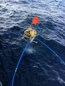
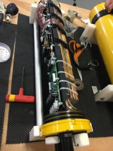
The current Scripps OMBT instruments look like giant 4-legged crabs. Silver-silver chloride electrodes sit at the four ends of the arms – 10 m apart. Two magnetic coils cross-cut the central unit and are wrapped around something called mu-metal, a nickel-iron alloy used in magnetic shielding. The original use of mu-metal was to improve communication in submarine telegraph cables using inductance. The signal from the coils needs to be amplified and the induced electric field is also measured simultaneously. Unlike the OBSs, most of the power in an OBMT is used for data logging. Power comes from 40 alkaline D-cell batteries. These and the electronics are housed in an aluminium-alloy tube (below, left). This is a high-strength, but light, alloy and is commonly used in aircraft components. The tubes are evacuated, and desiccant is used to absorb any moisture.
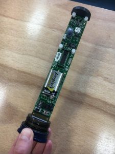
It is important to know the orientation of the electrodes and coils. Unlike the OBSs, the MT instruments are equipped with compasses. Once a day a Honeywell electronic compass (above right) logs the instrument heading, roll and pitch. It is mounted high up on the frame, to be clear of any magnetic parts of the instrument. One of our stations has shown changes in orientation, suggesting that it landed on a slope and moved a bit with time.
The OBMT clock is similar to that used in the OBS stations, as are the acoustics for communicating with the instrument. The acoustics have slightly better firmware, in that an operator can continue to communicate with the instrument during the burn and release sequence. A 120 kg anchor is made of a concrete slab reinforced by a stainless-steel frame. It acts as a steady 80cm x 80cm base for the instrument to sit on, and is nearly 9cm thick. Hooks from the frame attach it to the instrument in such a way that the burn wire and a spring mechanism release the instrument from the frame when it receives an acoustic signal to rise. As with the LDEO OBSs, buoyancy comes from evacuated glass spheres, which are 30cm in diameter. Some of the instruments have slabs of syntactic foam (more on this later) on them, which adds further buoyancy, but cannot be used in depths greater than 4km. They rise at a rate of 20-25 m a minute, so at some of our very deep sites we wait well over 4 hours. The deepest they can be deployed in the ocean is 6km.
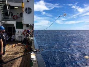
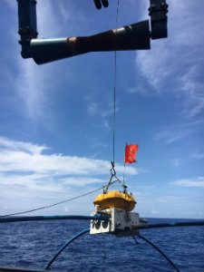
Of the five spheres, one serves as a beacon that floats a short distance from the main instrument package. It contains a strobe light, a radio frequency modem, and a GPS transmitter, which are used to find the instrument when it pops up at the surface. When the instrument is near the ship, a plastic grappling hook is thrown over the tie line between the instrument and the beacon sphere. This is used to pull the beacon out of the water and to pull the instrument toward the ship so that the crane can hoist it out of the water. Here is Kate throwing the hook, and then a shot of the OBMT on the end of the crane hook.
These are the longest deployments these instruments have seen, both in terms of recording time and time on the sea floor. This should mean that these instruments will probe the conductivity of the Earth well into the sublithospheric mantle.
