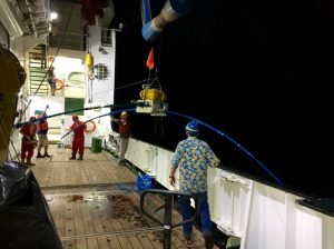
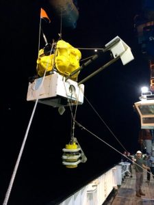
Finally, after nearly 6 days of sailing we arrived at our first site – L39D – where we retrieved one of the Lamont ocean-bottom seismometers (OBS) and a Scripps ocean-bottom magnetotelluric (OBMT) instrument. We arrived on site at almost 17:00 and we finished at midnight. Much of this time was spent trying to communicate with the instruments, which have been peacefully lying on the sea floor for a year and at first seemed reluctant to wake up.
A transducer is used to locate and communicate with the instruments. It can send commands to tell the instrument to release its anchor and rise to the surface. The OBMT takes roughly 4 hours to rise in 4000m of water, whilst the OBS takes 90 minutes. When they reach the surface a signal is sent to receivers on the ship, but they are also equipped with a strobe light and a bright flag. Additionally, the OBMTs have a GPS locator on them.
So, the procedure is to stop the boat at a distance equivalent to roughly half the depth of the water, which is normally a reliable distance to start communicating with the instruments. Our instruments are in water that varies in depth from 2900m to 5200m. With our experiment, we first communicate with the OBMT and send it on its way to the surface. We then do a sounding survey at various points roughly equidistant from the drop-site of the OBS. This is to find and locate the OBS (the deployment drop location is used for the OBMT, as station-location accuracy is less important for these instruments). Ideally one would sail in a circle around the likely site of the OBS and triangulate to locate it. In this first pick-up, we used the overboard transducer at four points of a diamond. When we finish surveying in the location of the instrument, the OBS was sent a signal to release its anchor and return to the surface.
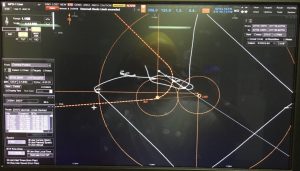 The diagram, left, shows in orange the circle with a radius of half the water depth, the proposed ship trajectory (dashed line) and the location of the drop point of the OBS (in the centre) and the OBMT (to the left) – the smaller circles are 500m around the OBMT and OBS. The white line shows the actual ship track, which starts near the OBS, then shows the diamond shaped survey used to locate the OBS and then the final area where the instruments were picked up. Due to the 1 knot current, the OBS and OBMT respectively drifted roughly 500m and 1000m away from the deployment location.
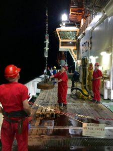 The transducer transmits the time it takes a signal to propagate from the ship to the instruments and back. To determine how far away they are, one needs to know the speed of sound in the water column. In the ocean, this varies as a function of pressure, temperature and salinity, in a somewhat complicated manner. Furthermore, the profile of soundspeed varies both temporally and spatially in the ocean. A well-known low velocity region lies between 500m and 1000m (the SOFAR channel), which serves as a wave guide that transmits energy great distances. For this reason, submarines try to avoid detection by staying out of this channel and whales use it to communicate. Due to the variability in soundspeed, we acquire what is known as a soundspeed vertical profile (SVP) to a depth of 700m. This is where all the action is – the deeper parts of the oceans are a bit more predictable. This picture shows the SVP probe attached to a 500kg weight – the Bosun uses a winch and crane to lift and lower into the water. This procedure takes roughly 30 mins.
As with any geophysics fieldwork, there are always unexpected problems in the field. With our cruise, the ship’s transducer is currently being awkward. We could not establish communication with the instruments from the lab and the reason for this was not readily apparent. We then tried to circumvent the ship’s wiring by patching into the transducer cable at the point it enters the ships wiring – this was done in a tiny, hot, crowded little room called the ‘hole’. Ship noise and bubbles will also interfere with the signal. We therefore turn off the other equipment that surveys water depth (e.g., the swath bathymetry) and we can get the Bridge to even turn off the propeller, thrusters and dynamic positioning on the ship. Furthermore, the transducer is housed in a keel that can be dropped below the ship. Finally, if this doesn’t work we can lower a transducer over the side of the ship to a depth of 20-60m. Thus far, we have tried all the above in a variety of configurations. Going forward, the best solution, which optimises speed and accuracy, seems to be to work in the ‘hole’ with the keel dropped. With each instrument the procedure will become more and more routine.
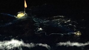 Recovering an instrument is exciting. There is regular communication between the Bridge, the main lab, the OBS or OBMT labs and the deck – everyone has walkie-talkies. The transducers can be used to interrogate the depth of the instruments as they rise. When they hit the surface, everyone looks for the strobe light (or flag in the daytime) on the beacon, but in practice the Bridge is always the first to see it. Our first recovery was in the dark, which made it a bit easier to see the light. The crew control the ship with amazing accuracy and using the various thrusters they can slide up alongside the instrument. 2-3 people then use hooks attached to poles to pull the instrument to the side of the boat and the instrument is attached to a crane. The Bosun (or Boatswain) uses the crane to hoist the instrument on to the deck. In general, he helps us with most of the logistics on deck. The whole procedure only takes 10-15 minutes – but this can take a lot longer in rough water.
The pictures below show the OBMT (left) and OBS (right) coming on board. 2 down – 76 more to go.
